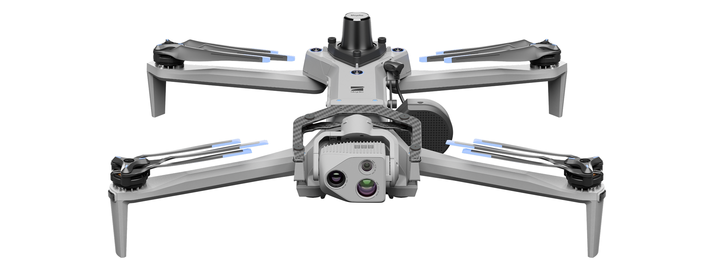
The Q6 V2 is a Drone developed by ideaForge (India), launched 2025, listed at $29,693 USD (unverified). Key specifications: airframe multirotor UAV, flight time 1.2 h, top speed 10 m/s, mission payload 6 kg.
Robo Index
Adequate evidence
7 of 10 signals present
Recomputed nightly from public data. Missing data is skipped, never zero-filled — and rankings are never for sale.
Weighted factors
average of the 7 scored · blanks don't count
Will it fit your job?
Tell us the job in plain words — we'll show how this robot measures up, line by line.
Tell us what your job needs — payload, budget, region, must-have certifications — and we'll show how Q6 V2 measures up, requirement by requirement. The Robo Index (trust) above is shown for every buyer, regardless.
Overview
Q6 V2 is a mapping and surveying UAV from ideaForge designed for geospatial data collection and reliable operations. Part of ideaForge's indigenous unmanned aircraft systems with industry-leading specifications and capabilities. The UAV has been tested in extreme weather conditions from deserts to glaciers across India.
Buyer decision signals
Deployments
Border Security Force (BSF)
Viability
Q6 V2 GEO cleared for commercial deployment in India
Price
Aggregated from public sources — unverified
Certifications & autonomy
Specifications
Category: Drone- Airframe
- multirotor UAV
- Flight time
- 1.2 h
- Top speed
- 10 m/s
- Mission payload
- 6 kg
- Takeoff weight
- 6 kg
- IP rating
- IP53
- Operating temp
- 0°C to +50°C
- Pricing model
- purchase
- Price tier
- 40-80K
Company profile
- Funding raised
- $53.8M
- Founded
- 2007
Detailed specifications
Safety & certifications1
- Safety Certification
- DGCA certification[3]
Other10
- Fleet Software
- BlueFire Live!
- Company Country
- IN
- Controller Model
- BlueFire Touch[1]
- Deployment Notes
- Backpackable portability for fast field deployment, less than 10 minutes deployment time[1][6]
- Youtube Video Id
- 7HQMwnUnufI
- Compatible Vision
- dual EO/IR payloads,30x HD optical camera,512p thermal imaging payload,high-resolution 24.3 MP photogrammetry camera,16 MP multispectral 4-band camera,LiDAR,oblique imaging,hyperspectral sensing,thermal detection
- Software Platform
- BlueFire Live!
- Training Required
- basic_<1day
- Programming Interface
- no_code_gui,proprietary_app
- Additional Information
- ideaForge ranked 5th globally in 2023 as a top dual-use drone manufacturer by Drone Industry Insights.,Backed by investors including Qualcomm, Infosys, and Celesta Capital.,Largest operational deployment of indigenous UAVs across India.,The Q6 V2 is an enhanced version of the renowned Q6, known for reliability and effectiveness in defense, civil, and enterprise sectors.,DGCA type certification confirms compliance with stringent safety requirements.,Product is a UAV/drone, not a ground robot; categorized as 'cleaning' per schema for aerial inspection/surveillance use cases.
Who runs it· deployment evidence
1 on record · none maker-verified yet. Each links to its source — open it and judge.
- Border Security Force (BSF)· Indiasource ↗
Where to buy
Get a price or reach an authorized seller — pick your region, then request a quote.
No authorized seller is listed for this robot yet — request a quote below and we’ll connect you with ideaForge or an authorized seller.
Request a quote — goes straight to ideaForge.
Every authorized seller serving your region is shown equally — placement is never sold, and this data never affects a robot’s score. A seller’s absence here doesn’t mean they aren’t authorized.
Company milestones
- May 2026AwardQ6 V2 GEO cleared for commercial deployment in India
- Aug 2025LaunchQ6 V2 GEO introduced publicly
- Aug 2025LaunchQ6 V2 GEO launch date announced
- Aug 2025LaunchQ6V2 GEO worldwide debut at PRAGYA 2025
- Mar 2025MilestoneNETRA 5 promotional post
- Aug 2024AwardQ6 V2 receives DGCA certification
- Dec 2023MilestoneSWITCH UAV promotional flight video
- Jul 2023MilestoneIPO listing
Compare with peers
Frequently asked questions
- Who makes the Q6 V2?
- The Q6 V2 is developed by ideaForge, based in India.
- What type of robot is the Q6 V2?
- The Q6 V2 is a Drone made by ideaForge.
- How much does the Q6 V2 cost?
- The Q6 V2 is listed at $29,693 USD in the Robolist catalogue, but this figure is unverified and not confirmed by ideaForge — contact them for a quote.
- When was the Q6 V2 launched?
- The Q6 V2 was launched in 2025.
- What are the key specifications of the Q6 V2?
- Key specifications of the Q6 V2: airframe multirotor UAV, flight time 1.2 h, top speed 10 m/s, mission payload 6 kg, takeoff weight 6 kg.
Reviews for Q6 V2
Loading reviews…